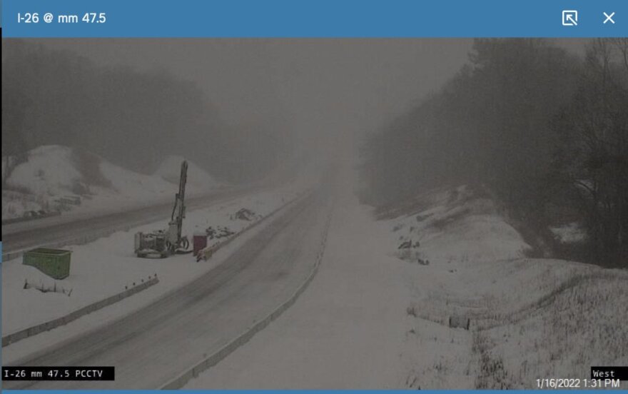
(Sunday 5:30 p.m.) About 8,000 Duke Energy customers were without power late Sunday afternoon in Western North Carolina after a storm that dropped close to a foot of snow in some areas passed through the region.
The areas with the highest number of outages are Qualla and Whittier to the west, and in Fairview to east of Asheville. A Duke Energy spokesman said while the number of outages has steadily gone down Sunday afternoon as crews work, it's possible there will be some new outages overnight due to heavy winds overnight. (SEE DUKE ENERGY OUTAGE MAP) Additional snowfall is forecast for overnight, with winds gusting up to 45 miles per hour.
The National Weather Service in Greenville/Spartanburg reported Asheville and Buncombe County received between 7 and 8 inches of snow as of late Sunday afternoon depending on elevation. Areas in Transylvania and Haywood County above 4-thousand feet received the most snow in the region at almost a foot. As much as four more inches could fall overnight according to the weather service, again depending on elevation. Low temperatures are expected to be in the teens. A winter weather warning for the region remains in effect until 8 a.m. Monday.
Schools were already scheduled to be off Monday for the Martin Luther King Jr. holiday. Road conditions are expected to be treacherous for those working Monday. The North Carolina Department of Transportation is urging patience as plows work to clear roads. “Even after the storm passes, we ask North Carolinians to be patient as our crews and emergency responders do their important work to clear the roads,” State Transportation Secretary J. Eric Boyette said Sunday in a statement. “Everyone should avoid driving in these conditions. There’s no need to take any unnecessary risks.”
(Saturday 7:15 p.m.) While expected snow fall totals are dropping, all of Western North Carolina remains under a winter storm warning until Monday morning, as snow is expected to start falling in earnest late Saturday.
The National Weather Service in Greenville/Spartanburg forecasts Asheville and most Buncombe County to receive just 4 to 6 inches of snow from the storm, down from 8 to 12 as previously forecast. Transylvania County and parts of Haywood will now see the highest snow fall totals in the region, with a foot or more expected depending on elevation.
Slightly warmer temperatures will mean that snow will at times fall as sleet or freezing rain, making travel treacherous. The North Carolina Department of Transportation urged motorists on Friday to stay off roads as much as possible once the storm hits, both for safety and to allow snow plows as much room as possible to clear roads.
(Friday 5:45 p.m.) Road crews began their preparations for this weekend's snow storm by pre-treating roads with salt brine, as upwards of a foot snow is forecast to fall in parts of Western North Carolina beginning Saturday evening.
The National Weather Service in Greenville/Spartanburg has upgraded to a winter storm warning for most of Western North Carolina starting at 6 p.m. Saturday and lasting until 8 a.m. Monday. Only Clay and Cherokee Counties do not fall under the warning, though both are still under a winter storm watch. Depending on elevation, the region will receive between 6 and 20 inches of snow, with areas to the north and west of Asheville receiving lower amounts and spots above 4-thousand feet in elevation - mostly in Transylvania and Jackson Counties - receiving the most. Asheville and Buncombe County are still forecast to receive 8 to 12 inches of snow.
Scott Killough of the North Carolina Department of Transportation says the more people stay at home right now, the more effective his crews can be. “The less traffic we have to deal with and the less impacts from accidents and traffic backups, the easier our job will be and the quicker we can get done," Killough told reporters Friday in Asheville. He added the length of the storm, combined with the cold temperatures after the snowfall, could extend the amount of time it takes before his crews can get to secondary roadways. That's especially true because Killough says they’ve experienced staffing shortages due to COVID. "Our personnel numbers are down with what we have available. At any given time, we have a number of employees that are affected or quarantined, so we’ve worked through that some. There is a bit of a shortage across the entire division," Killough said.
(Friday 1:30 p.m.) A major snowstorm is forecast to hit Western North Carolina late Saturday into Sunday, leaving as much as a foot of snow or more throughout the mountains.
The National Weather Service in Greenville/Spartanburg has issued a winter storm watch from late Saturday night through Sunday evening for the region. Asheville and Buncombe County are forecast to receive 8 to 12 inches of snow during that time. The rest of the region is forecast for varying snowfall totals, with areas above 4,000 feet in elevation seeing up to 20 inches of snow.
Road crews began their preparation for the storm Thursday. North Carolina Department of Transportation trucks began applying brine to roads ahead of the storm. The initial focus from state crews was on the Interstate 26 construction zone in Buncombe County. In Asheville, crews began their brine treatment Friday afternoon. The city says it will make parking garages free sometime Saturday in Asheville's central business district in order for vehicles to be moved off of streets, allowing plows more room to clear streets once snow starts falling.
“After the storm hits, please stay home and off the roads,” said NCDOT Chief Operating Officer Beau Memory said in a statement. “NCDOT and contractor crews will do the best they can to clear roads as quickly as possible, but we ask everyone to be safe and stay patient.”
This story will be updated as events necessitate.


